Raja Ampat’s rich reefs and abundant seas provide a multitude of ecosystem services to local communities, along with a variety of domestic and international industries. From traditional use and food security, through to fisheries and a thriving tourism industry; a variety of stakeholders derive benefit from the regions marine resources.
In order to protect these resources from inordinate exploitation and unsustainable use, and to ensure the long-term protection of marine environments, in 2004 the first of 9 Marine Protected Areas (MPAs) was established. This network of MPAs now covers 2,000,109 hectares which together form the Raja Ampat Marine Park, under provincial and national jurisdiction.
Each Marine Protected Area contains specific zones, which help to manage and protect natural resources by applying rules that define the activities that are permitted, the activities that are prohibited, and the activities that require a permit. Zones may also place restrictions on how some activities are conducted.
Zoning is an integral component of management of Marine Protected Areas; it is a key strategy in sustaining and improving reef health and resilience, leading to healthy and productive reefs throughout the region, which in turn provides food security, regional stability, and economic and health benefits to local communities and a range of local and international stakeholders.
The Raja Ampat Marine Park Management and Zonation Plan 2019-2038 makes provision for a range of ecologically suitable commercial, recreational and research opportunities within Marine Protected Areas, along with supporting traditional usage and related practices.
Marine Protected Areas & their Zones:
What can you do where?

ZONING IN RAJA AMPAT'S MARINE PROTECTED AREAS
This Zoning table outlines which activities are permitted or forbidden in each of the MPA Zones. This zones are clearly marked on the corresponding maps for each of Raja Ampat’s Marine Protected Areas.

DAMPIER STRAIT MPA: 353,531ha
The Dampier Strait Marine Protected Area stands as the second most expansive MPA in Raja Ampat. Divided into three distinct regions this MPA includes the shoreline zones of Gam and Mansuar Islands, the coastal stretches of Batanta Island, and the coastal areas on the northern and northeastern parts of Salawati Island.
Where Raja Ampat is at the heart of the Coral Triangle, the Dampier Strait is at the heart of Raja Ampat. The strait benefits from strong oceanic currents that flow from the Pacific Ocean, coupled with upwellings of deep-sea waters that carry a wealth of nutrients into the strait’s waters. This creates an ideal habitat for marine species to prosper and for coral ecosystems to thrive.
Celebrated for having the richest biodiversity across Raja Ampat, the Dampier Strait MPA is well known for its vivid coral reefs and the diverse marine life. The area serves as a magnet for large pelagic species such as sharks, tuna, snapper, grouper, barracuda, and trevally. Additionally, the Dampier Strait also provides a critical refuge and migratory pathway for various marine mammals, including whales, dolphins, and dugongs. It is notably acclaimed for it’s seasonal aggregations of both species manta ray.

FAM ISLANDS MPA: 357,383ha
Directly bordering the Halmahera Sea, the Fam Islands Marine Protected Area is distinguished by its small karst islands, and has risen in popularity and development as tourists visiting Raja Ampat are drawn by its stunning natural landscapes both above and beneath the sea’s surface.
Among these mostly uninhabited Fami islands, three villages have been established: Fam Village on the smaller Fam island, along with Saukabu and Saupapir on the larger Fam island. In addition to these communities, there exist a few other smaller settlements functioning as business hubs or temporary housing for fisherman.
The establishment of the Fam Islands MPA was initiated by the local community, aiming to conserve the rich marine life that thrives in the waters around these islands, and this area achieved a formal declaration of the Fam Islands MPA in January 2017.
The coral reefs around the Fam Islands burst with life, hosting extensive stretches of hard coral and a variety of marine species. Predatory fish such as sharks and tuna, colorful reef fish like anthias and damsels, and ancient Tridacna Clams are found amidst the dense coral gardens. Surrounding waters serve as critical habitats for emblematic marine species, including sharks, Napoleon fish, two turtle species, both manta ray species, and marine mammals like whales and dolphins. The Fam Island MPA is also notable for housing the world’s largest land crab, the Coconut Crab (Birgus latro), a species under protection in Indonesia. Despite protective measures, there have been instances of Coconut Crabs being captured and sold, an illegal activity in Raja Ampat and across Indonesia, and punishable by law.

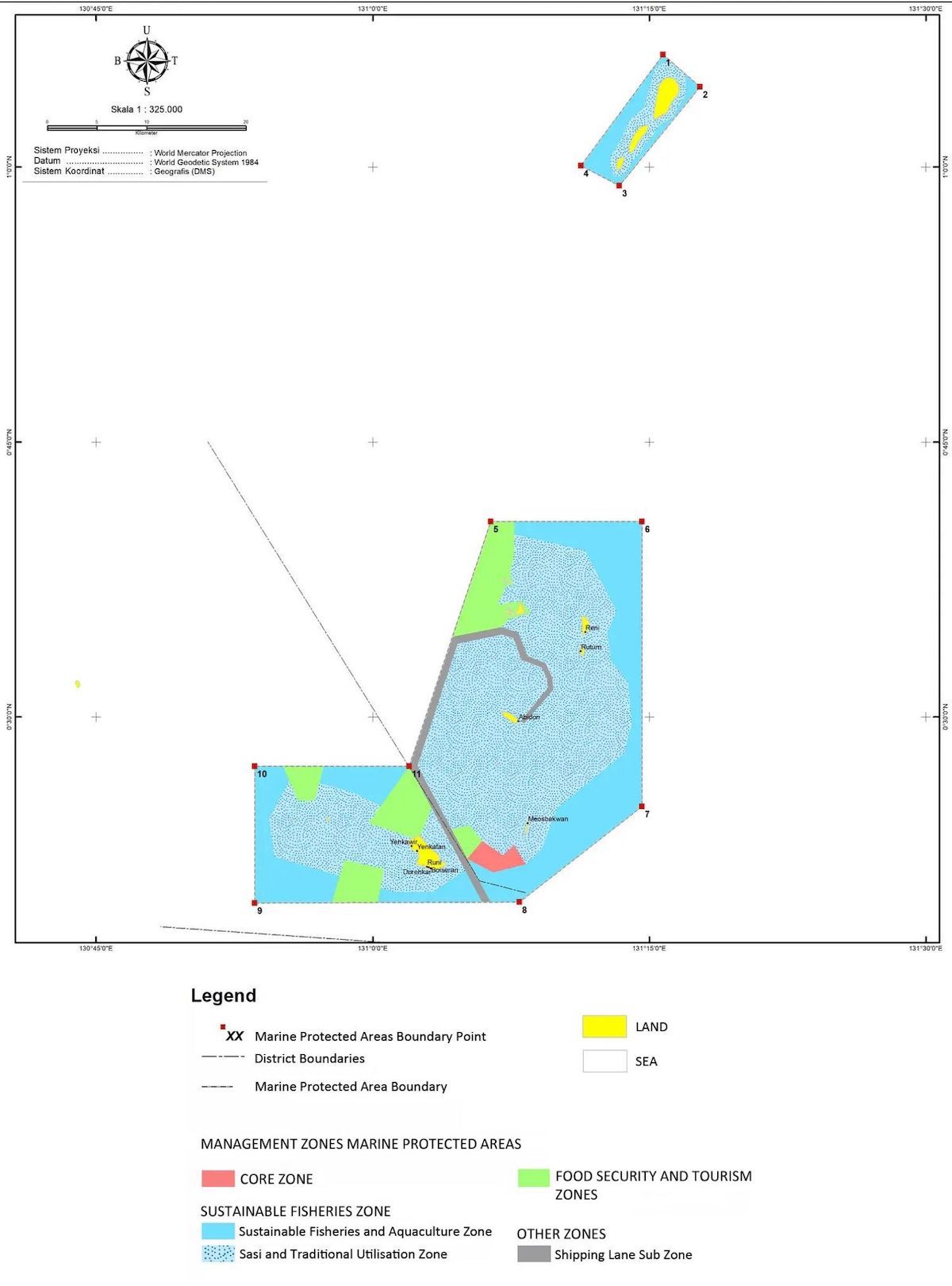
ASIA & AYAU ISLANDS MPA: 99,339ha
Adjacent to Palau and the Philippines, the Asia Ayau Islands mark some of Indonesia’s most distant territories, with the Asia Ayau Marine Protected Area encompassing 99,339 hectares.
This MPA features a vast coral reef bank and atoll among its island surroundings. Celebrated for hosting the most significant grouper spawning grounds in Eastern Indonesia, this sensitive ecosystem is crucial for supplying grouper fish and eggs to the Maluku and Halmahera regions, as well as extensive portions of Papua’s Bird’s Head Seascape.
The Asia Ayau Islands Archipelago serves as a critical area for economically valuable fish species including napoleon wrasse, trevally, tuna, skipjack, and other pelagic species like mackerel. Additionally, this MPA recognized for it’s significant, highly senstive sea turtle nesting sites, accommodating both the Green Turtle (Chelonia mydas) and the Leatherback Turtle (Dermochelys coriacea). The local waters are also home to Bottlenose dolphins (Tursiops truncatus), spinner dolphins (Stenella longirostris), and sperm whales (Khazalie et al., 2011).
Being such a remote area, communities here depend upon a continued state of reef to survive, relying heaving on fishing to survive. Given it’s location and grouper spawnings, during the 1990s, Hong Kong vessels frequented Ayau to purchase live groupers directly from the locals for export – profiting greatly from the practice whilst depleting the seas for local people. This activity, along with destructive fishing practices like blast fishing and cyanide use, have largely ceased with the establishment of the Asia and Ayau MPA in 2007, although on occasion, illegal fishing vessels or practices occur the area.

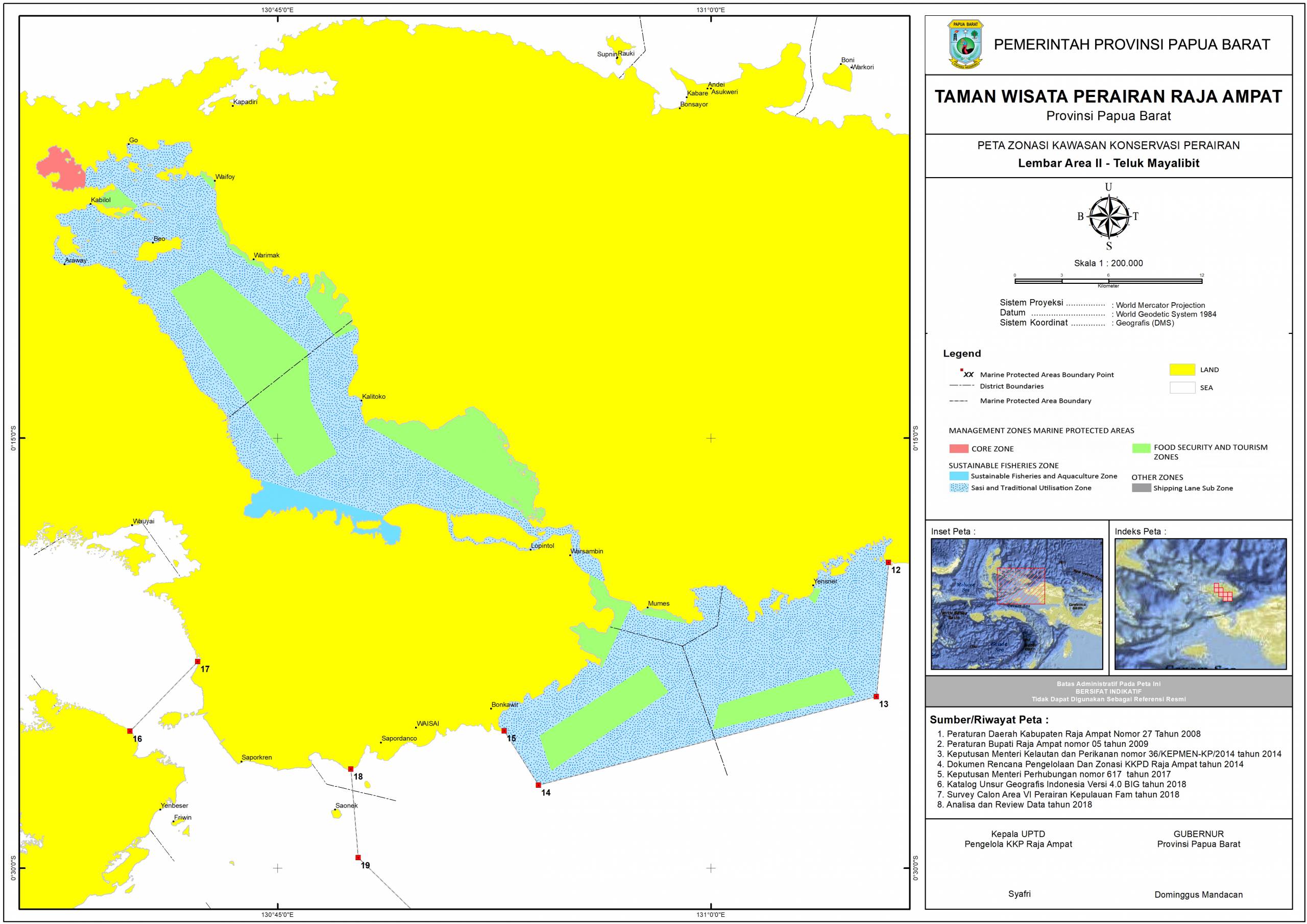
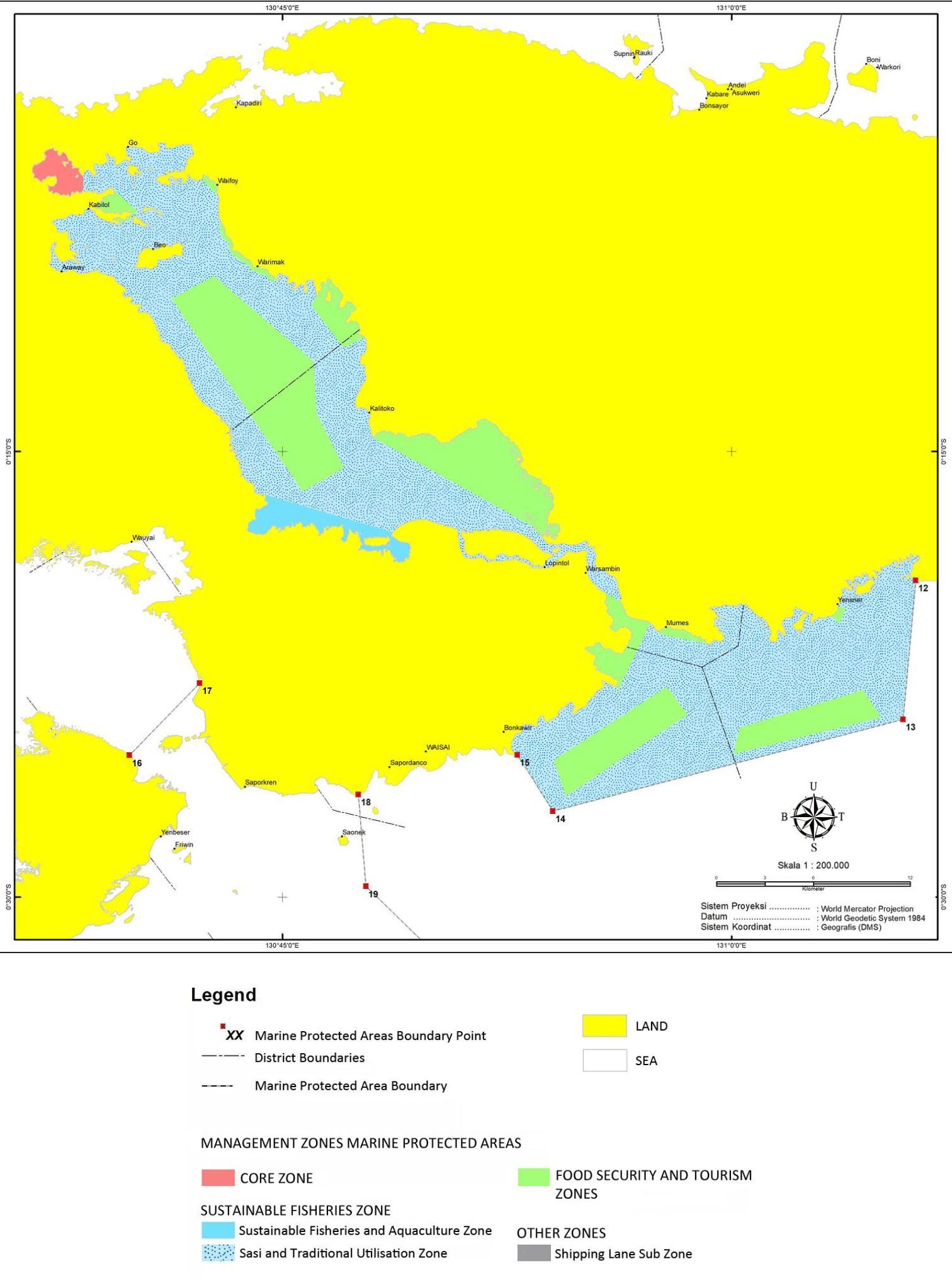
MAYALIBIT BAY MPA: 40,451ha
Covering an expanse of 49,451ha, the Mayalibit Bay Marine Protected Area (MPA) nearly divides the island of Waigeo in half. The bay is distinguished by its extensive mangrove forests and seagrass beds, with seagrass extending about 70 meters from the mangrove edges to the shoreline. While the presence of hard corals is limited, the bay is thought to be a crucial habitat for economically valuable marine life such as mackerel, rabbitfish, shrimp, trevally, snapper and mud crab (Scylla), making it a critical area for marine biodiversity and conservation.
This area is markedly different from the more well known areas of Raja Ampat; a narrow mouth opens into a vast, cliff lined bay, containing large networks of mangrove and seagrass and surrounded by dense, primary rainforest. Rivers and inlets snake their way through the forest, which can occasionally be followed to their source.
Mayalibit Bay is considered the ancestral home of the Maya people, the indigenous inhabitants of Raja Ampat, residing in 11 villages and 1 hamlet within the bay.
Mayalibit Bay was officially designated as a Marine Protected Area on November 15, 2006, following a customary declaration by the Waifoi village community, and was the first MPA within Raja Ampat.

KOFIAU BOO ISLANDS MPA: 148,979ha
The Kofiau-Boo Islands Marine Protected Area (MPA), situated at Raja Ampat’s western frontier, encompasses an area of 148,979 hectares. This MPA is home to 44 islets in two clusters: the eastern Kofiau Islands and the western Boo Islands, together constituting the Kofiau District.
Renowned for its rich diversity of coral species, the area boasts an average of 292 coral species per site, showcasing an exceptional level of biodiversity for islands of its size. Coral reefs span 13,800 hectares within the MPA, while mangrove forests cover an additional 3,413 hectares.
Beyond its coral and fisheries, the Kofiau-Boo Islands MPA serves as a vital migratory passage for various cetaceans and marine mammals, including sperm whales, killer whales, bryde whales, bottlenose dolphins, Indo-Pacific bottle-nosed dolphins, and dugongs.
The indigenous population of the Kofiau-Boo Islands, descendants of the Betew Tribe, share linguistic and cultural ties with the Biak Tribe from the northern part of the Bird’s Head Seascape. The primary sources of livelihood for these communities include fishing and seasonal agricultural activities such as copra production.
In line with the broader Raja Ampat region’s practices, the local communities of the Kofiau-Boo Islands employ the traditional ‘Sasi’ resource management system. This method regulates the use of natural resources by permitting or prohibiting specific activities in designated areas to ensure sustainable management.
This approach, complemented by No Take Zones and Utilisation Zones, plays a crucial role in the enhancement and stewardship of local fisheries and marine ecosystems.

NORTH MISOOL MPA: 313,708ha
In March 2018, the North Misool Marine Protected Area was formally acknowledged as an MPA by the local community, in partnership with Yayasan Nazareth Papua and Conservation International. This endorsement reflected the shared vision of the Matbat and Matlou communities residing in North Misool’s nine villages, to designate 313,708 hectares of their marine territory as a conservation area.
North Misool’s marine ecosystem, though less explored compared to other regions in Raja Ampat, has been recognized for its biodiversity. The area is frequented by marine mammals such as dolphins, Bryde’s whales, orcas, and whale sharks. It’s also a critical habitat for sharks, manta rays, and notably, hosts significant populations of saltwater crocodiles in its northern rivers.
A notable conservation effort in North Misool is the dugong surveillance program initiated in 2008 by Yayasan Nazareth Papua and the community, aimed at identifying and conserving dugong feeding areas. This initiative has grown into a broader conservation project, including patrols to monitor dugong populations.
Although rich in biodiversity, North Misool faces challenges from illegal and destructive fishing practices, such as bomb and cyanide fishing, and the poaching of protected species. The area’s remoteness and limited access exacerbate governance and conservation challenges.

MISOOL ISLANDS MPA: 346,189ha
The Misool Islands Marine Protected Area, positioned in Raja Ampat’s southernmost region, spans over 346,189 hectares.
Renowned for its diverse marine life, the Misool Islands are especially famous for their flourishing soft coral ecosystems. The underwater landscape features rocky formations, coral pinnacles, and shelters teeming with a variety of marine life including enormous gorgonian sea fans, vibrant tunicates, swarms of jacks, barracudas, and even larger gatherings of fusiliers. Frequent sightings of groupers and reef sharks add to the area’s allure, alongside the mesmerizing presence of pygmy seahorses and diverse nudibranch species decorating the coral habitats.
The richness and diversity of the reefs are attributed to the area’s proximity to the Ceram Trough’s deep waters, which facilitate nutrient upwelling from the Indonesian Throughflow moving south towards the Banda Sea.
The MPA also features secluded beaches that are vital nesting sites for green and hawksbill turtles, regions frequented by aggregating manta rays, and river estuaries home to saltwater crocodiles.
The Misool Islands are also home to abundant mangrove forests, including rare Bluewater Mangroves, which servei as critical habitats for various fish, shrimp, and crabs, crucial for local sustenance.
In the early 2000s, the Misool Islands faced threats from destructive fishing methods. To combat this, a joint initiative in 2005 between the local community and Misool Eco Resort established the first No Take Zone. This effort has expanded into a comprehensive conservation program led by the Misool Foundation, working closely with the Raja Ampat Marine Park Authority to safeguard the area through regular patrols, radar, and drone surveillance, significantly increasing marine biomass and shark populations within the protected zones. This collaborative model, emphasizing sustainable tourism and the traditional ‘sasi’ practice, is crucial for the ongoing protection and management of the Misool Islands’ marine and terrestrial resources.

RAJA AMPAT ISLANDS & SURROUNDING SEAS MARINE RESERVE: 57,875ha

Marine Protected Area Regulations
To safeguard Raja Ampat’s unparalleled marine ecosystems, all individuals and organisations are required to adhere to the established Regulations and Codes of Conduct. These guidelines are essential for ensuring the sustainable management of Marine Protected Areas and the wider region, protecting the vibrant coral reefs and abundant marine life for generations to come.
By following these regulations, we can help maintain sustainable fisheries, secure the food resources, culture and heritage for local communities, and support eco-tourism and other livelihoods that depend on the health of these ecosystems.
For detailed information, please review the Regulations and Legal Framework below, which form the foundation of sustainable use and management within Raja Ampat Marine Park, as outlined in the Management and Zoning Plan – Raja Ampat Marine Protected Areas 2019-2038 and as supported by the Legal Framework.
Permits
Tourists and Visitors
All tourists and visitors are required to purchase their Marine Park Entry Card prior to entering.
All Vessels
All Vessels (commercial and recreational) must ensure they have the operational permits relevant to their activities within the Marine Park.
Zoning
Zoning
Each Marine Protected Area contains specific Zones with rules that define the activities that are permitted, the activities that are prohibited, and the activities that require a permit.
All individuals and organisations must abide by Zoning Regulations, please refer to the specific Zoning Maps for details relevant to each Protected Area.
Core Zone: A conservation zone (a ‘No-Go Zone’) designated based on the highly ecological significant ecological value. Access is granted only through restricted permit that covers limited purposes.
Food Security and Tourism Zone: Commonly known as a “No Take Zone”. All forms of fishing are prohibited within these Zones. Food Security and Tourism Zones also accommodate sustainable tourism activities.
Sasi and Traditional Utilisation Zone: Zone specifically designated for the benefit of the local community that supports local, sustainable fishing activities and cultural practices. Traditional Utilisation Zones also accommodate Sustainable Tourism Activities.
Sustainable Fisheries and Aquaculture Zone: Only limited commercial-scale fishing and aquaculture activities are allowed within this Zone, and are subject to sustainable management regulation. Sustainable Fisheries and Aquaculture Zones also accommodate sustainable tourism activities.
Shipping Lanes: This zone is devoted to shipping lines who must remain within the lanes at all times.
Prohibited Activities
The following activities are strictly prohibited and considered violations against Raja Ampat Marine Park regulation. Conducting any of the activities listed below can result action against the perpetrator(s). Some activities, as identified, are permitted under special Zoning, permit or quota regulation.
Protected Species
Raja Ampat Regency is a Shark Sanctuary, and all sharks are protected within its waters. The Marine Park also offers protection to a number ecologically and economically important ocean species including (but is not limited to) sawfish, guitarfish, wedgefish, shovelnose rays, mobular rays, cownose rays, devil rays, eagle rays, bull nose, mobular, bull ray, marble ray, and all marine mammals.
Both species of Manta Ray (M. birostris and M. alfrediei), and all species of Sea Turtle also receive full protection status under the law of the Republic of Indonesia.
Click Here for a full list of Protected Species
With respect to species listed as protected, any and all persons are prohibited to:
- Catch, injure, kill, keep, posses, care for, transport and trade in a protected animal species in a live condition.
- Keep, posses, care for, transport and trade in a protected animal species in dead condition.
- Transfer a protected animal species from one place to another, both inside and outside Indonesian borders
- Trade, keep or posses skin, bodies or other parts of a protected animal, or goods made of parts of the animal, or transfer from one place in Indonesia to another, within or outside Indonesia.
- Take, destroy, exterminate, trade, keep, or posses eggs and/or a nest of a protected animal.
Violation of Sasi (Traditional Resource Management Zone)
Local communities in Raja Ampat practice ‘sasi’ as a means to sustainably manage natural resources. With respect to marine environments, this can be opening and closing access to certain areas for fishing, and/or restricting or limiting specific activities.
All Local Community sasi’s must be respected.
Littering: Rubbish and Trash
Littering in any form is prohibited. This includes the unsuitable disposal of rubbish by not using bins provided, burying, dropping or leaving rubbish on land, dropping or dumping rubbish in the sea or any other waterways.
Damaging ecosystems or any other marine life
Damaging ecosystems or any other marine life is prohibited. This includes handling, harming or harassing marine life, or any willful or unintentional damage to any ecosystem within the park.
Spearfishing
It is prohibited for any tourists or visitors to be spearfishing for any purpose. (Local community members may use traditional spearfishing methods such as jubi and senapan molo, in Sustainable Fisheries and Aquaculture Zones).
Coral Mining
The removal of live corals from the water for uses including (but not limited to) bricks, road fill, cement or other construction material is prohibited.
Introduction of foreign biota
The introduction to Raja Ampat of any foreign species, plant or animal, that are not native to Raja Ampat Regency is prohibited.
Conducting Research without permit
Conducting scientific research without the required permits from relevant authorities is prohibited.
Feeding Fish and other Marine Species
Feeding fish or any other marine species is generally prohibited, particularly during tourism activities such as diving and snorkelling. Under the special conditions outlined in the Code of Conduct, fish feeding may occur at specific locations (only).
Seismic Surveys, Mining (oil and gas)
Seismic Surveys and all types of mining activities are prohibited within Marine Protected Areas.
Destructive and Unsustainable Fishing
The following methods of fishing are prohibited:
Blast Fishing: the use of explosives to stun or kill schools of fish
Cyanide Fishing: spraying sodium cyanide or potassium cyanide into marine habitats in order to stun and catch fish or other marine species.
Compressor Fishing: divers using breathing hoses attached to a surface air compressor in order to collect fish or other marine species
Trawler Fishing: actively dragging or pulling a trawl net through the water behind one or more trawlers, at either seabed, mid-water or specified depth.
Purse Seine Fishing: Using purse seine fishing techniques; a large wall of netting deployed to capture an entire area or school of fish
Longline Fishing: Use of a long fishing line (main line) with multiple baited hooks attached at intervals.
Unsustainable or Damaging Fishing Practice: any fishing practice that endangers sustainability of natural resources
Other Fishing Methods
Bagan Fishing: using boats with large nets and lights suspended underneath, to attract and catch large numbers of fish is prohibited.
Fish Aggregation Devices (FADs): Using floating objects (buoys, rafts attached to ocean floor) that are designed and strategically placed to attract fish is prohibited.
Fishing Vessels >2Gross Ton: Fishing Vessels >2GT are not permitted to conduct fishing activities within Marine Protected Areas. Fishing Vessels <2GT are permitted to conduct fishing activities within the Sustainable Fisheries and Aquaculture Zones, subject to permits and sustainable management regulation.
Fishing with SCUBA diving equipment: using SCUBA diving equipment for spearfishing or any other capture or collection of marine species is prohibited.
Sero: a traditional trap typically consisting of an array of fences that guide fish towards the trap. Existing Sero are permitted in accordance with regulation. The installation of any new Sero is not permitted.
Other nets and traps: Use of Muroami and gill nets is prohibited. (Traditional ‘bubu’ fishing traps are permitted in the Sustainable Fisheries and Aquaculture Sub-zones, and as long as there are permits from the local community members and are subject to catch quota. ‘Jala’ and ‘Jaring Belo’ is permitted in the Sustainable Fishing and Aquaculture Zones, as long as there are permits from the local community members and in accordance with Zoning Regulation and any other relevant regulation).
Catching Crabs and Prawns: is prohibited in Core Zones and No Take Zones. (Catching crabs and prawns is permitted in the Sustainable Fisheries and Aquaculture Sub-zones, as long as there are permits from the local community members and in accordance with Zoning Regulation and any other relevant regulation)
Bameti: the collection of fish, molluscs and crustaceans from reef flats at low tide is prohibited in Core Zones and No Take Zones. Bameti is permitted in the Sustainable Fishing and Aquaculture Sub-zones, as long as there are permits from the local community members and in accordance with Zoning Regulation and any other relevant regulation. Bameti fishing must not use any tools and methods that can damage coral reefs.
Capture of Ornamental Fish: the capture of any fish with the intention to use or sell for ornamental purposes is prohibited.
Aquaculture
Cultivation of Pearls: pearl farming is prohibited in all Zones, with the exception of Sustainable Fisheries and Aquaculture Zones, and after obtaining the required operational permits.
Fish Farms: fish farming (all species) is prohibited in all Zones,with the exception of Sustainable Fisheries and Aquaculture Zones, and after obtaining the required operational permits.
Ponds and Dams: constructing ponds or dams for the purpose of cultivating fish or other marine species is prohibited.
Damaging Coral
Damaging coral in any way is forbidden. This includes damage caused by stepping or walking on coral and coral reefs, cutting, moving or removing coral, boat strike or anchor damage to coral reefs, grafitti, defacing or writing on coral, or any other form of behavior that results in damage or destruction of coral.
Removal of Coral
The collection and removal of coral, dead or alive is forbidden.
Jetskis and Motorised Water Sports
It is prohibited to use jet-skis or any form of motorized water sport within the Marine Protected Areas (MPAs).
Collecting and removal of natural objects
The collection of natural objects (marine or terrestrial, living or dead), such as shells, fish, seahorses, coral or wood, for intended removal from Raja Ampat or Indonesia is prohibited within Raja Ampat Marine Park.
Collecting and removal of historical or cultural objects
The collection and removal of historical and cultural objects prohibited.
Mangrove Felling
The cutting or removal of mangroves is forbidden.
Sand Mining
The extraction of sand from beaches, sea bed or any other location, for use in manufacturing or construction is forbidden.
Legal Framework: Marine Protected Areas, Regency, Provincial and National Laws
The legal basis for securing and protecting the Raja Ampat Regency Waters and Raja Ampat Marine Protected Areas are supported by the following:
1. Governor of West Papua’s Decree Number 523/124/7/2019 on the Management and Zoning Plan – Raja Ampat Marine Protected Areas, West Papua Province 2019-2038 and the Management Plan 2019 – 2038 (actual).
2. West Papua Governor Regulation Number 4 of the Year 2019 on The Tariff for Maintaining Environmental Services by the Raja Ampat Marine Park Authority
3. Minister of Marine and Fisheries of the Republic of Indonesia’s Decree Number 63/KEPMEN-KP/2014 on Management and Zoning Plan Raja Ampat Islands and Surrounding Seas Nature Reserve in West Papua Province 2014-2034
4. Minister of Marine and Fisheries of the Republic of Indonesia’s Decree Number 36/KEPMEN-KP/2014 on Marine Protected Areas of the Raja Ampat Islands, Raja Ampat Regency, West Papua Province
5. Minister of Marine and Fisheries of the Republic of Indonesia, Decree Number Kep.65 / men / 2009, on the Establishment of the Conservation area of West Waigeo Islands and Surrounding Areas Marine Reserve in the Province of West Papua
6. Raja Ampat Regency Regulation Number 5 of the Year 2009 on Marine Protected Areas, Raja Ampat Regency
7. Raja Ampat Regency Regulation Number 27 of the Year 2008 on Marine Protected Areas, Raja Ampat Regency
100% of your donation goes to
the field.
Donateur français Cliquez ici
If left unchecked, 90% of coral reefs will be threatened by 2030, with almost all reefs facing, high, very high, or critical threat levels by 2050.
If we don’t act now, future generations will not have the privilege of seeing a live coral reef, let alone receive the benefits that coral reefs provide, including food, coastal protection, livelihoods and medicine.
In Raja Ampat, Indonesia, the most biodiverse coral reefs on Earth are under threat; rapid and unsustainable development combined with climate change threaten the future of these reefs, along with the food security, heritage and livelihoods of many.
Your contribution today has a direct impact in enabling our team to work with local people to Restore, Protect and Conserve reefs in the world’s last remaining coral stronghold.
We cannot do it alone, but with your contribution we can do it together.
Copyright © The SEA People 2016-2026. All rights reserved. This website is copyright monitored and protected.
Yayasan Orang Laut Papua is a registered NGO under the Ministry of Law and Human Rights Republic of Indonesia. Number AHU-0016408. Year 2019. The SEA People is a registered Charitable Association under the Gouvernement de la République in France (Numero Identification Siren 853074300) and serves as an administrative and fundrasing base for supporting the fieldwork of Yaysan Orang Laut Papua. Privacy Policy Terms & Conditions